
Travel from the central highlands of Windhoek to the Namib Desert and world renown Sossusvlei. To the Atlantic Ocean and Namibia’s Skeleton Coast, on to Etosha National Park for an excellent game viewing experience. The water rich northern areas are quite unlike the rest of the country, travel through the BwaBwata National Park as you make your way to Botswana and Chobe National Park ending with the natural wonder of Victoria Falls, Zimbabwe.
1 - 4 guests – Toyota Fortuner 4x4 / similar

If you are interested in booking this tour with us, please fill out the form below and we will get back to you.
Please make sure you filled out all the required fields marked with an *.
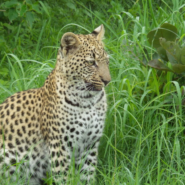
The Chobe National Park is the biggest in the Chobe/Kasane region. It is one of the largest parks in Botswana. Its landscape varies from floodplains, dense Mopane forests, and savanna to grasslands. You can expect to see a magnificent wealth of game, e.g. giraffes, a wide variety of Antelopes, Hippos, Buffalo, lions, bat-eared foxes, cheetah wild-dog, leopards etc. and also a massive population of elephants. Kasane is the main town of this region and is a tourist hub. Kasane also offers boat trips for game viewing on the Chobe River.
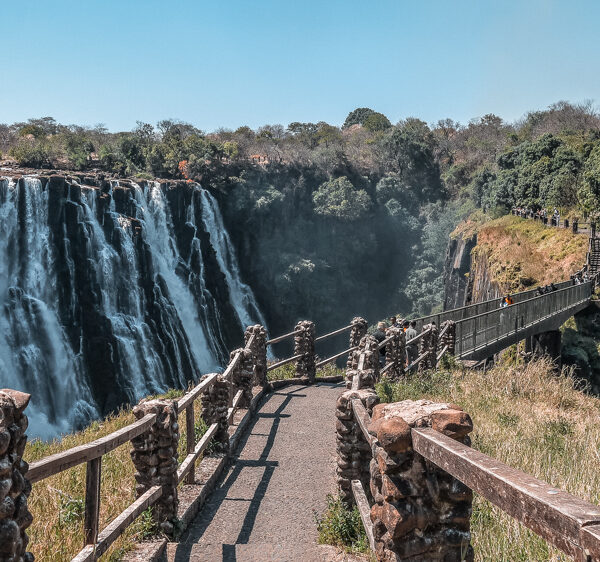
The Scottish missionary David Livingstone identified the falls in 1855, and naming them Victoria Falls after Queen Victoria. Since the mid 20th century, the site is growing to be a very important source of tourism to both Zimbabwe and Zambia, situated approx. 10km outside the city of Livingstone. It is known as one of the world’s seven natural wonders and one of the most spectacular natural sites in the world.
The Falls are 1.7 km wide with a volume of between 20,000 and 700,000 cubic metres per minute, falling down a vertical drop of 100 metres. The spray of the Falls can be seen from a distance of 30km and hereafter its local name, Mosi-oa-Tunya, “The smoke that thunders.”
Due to the increasing levels of tourism and the region’s development, it has become known as a centre for adventure sports. Activities gained attractiveness in the area, including white-water rafting in the gorges, bungee jumping from the bridge, game fishing, horse riding, kayaking, and flights over the falls.
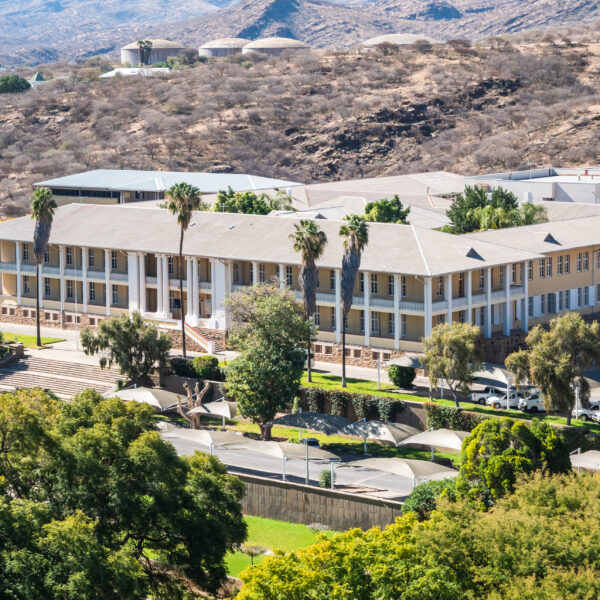
Windhoek, with its now over 500,000 inhabitants, is the largest city in Namibia. The pretty capital is located at an altitude of 1650 meters, in a basin of mountain ranges, lined by the Eros Mountains in the north and the Auas Mountains in the south. To the west, the Khomas Highlands stretch towards the Namib and the coast. The influence of the German language and culture can be seen in many areas due to the colonial past.
Particularly worth seeing are the “Ink Palace”, Namibia’s parliament building, the Christuskirche of the Lutheran community from 1896, the new bombastic Independence Museum right next to it and the “Alte Feste”, once the headquarters of the protection force and now the Namibian National Museum.
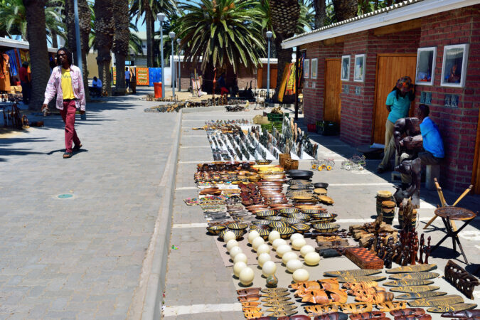
The environment is becoming denser and greener, trees are becoming more numerous. Free-roaming goats, sheep and cattle move between the settlements, and fields with corn and millet, and unexpectedly cross the roadway due to the lack of fences. On the roadside, woodcarvers sit in front of their huts and shelters and offer their carving work. The transport of water to the villages is unique, namely with environmentally friendly ox-drawn sledges.
The district capital, Rundu, is located on a small hill directly on the Kavango River. This is the lifeline of this region . Over a length of more than 400 kilometres, the Kavango River marks the border between Namibia and Angola before turning south into the Okavango Delta
200 Kilometers east of Rundu, near the village of Divundu, is one of the scenic highlights, the Popa Falls. The Popa Falls are not really a waterfall, but only rapids, which looks more impressive in deep water than in high water, because then the rock reef stands out more strongly from the riverbed.
The national parks such as Mahango Park are home to a range of animals, including hippos.

Swakopmund was of great importance as a port during the German colonial period. Since the coastal waters are actually too shallow, a protected bay is missing and the surf is too strong, this attempt has failed.
Today Swakopmund is a popular holiday town for visitors offering many tourist attractions.
Swakopmund’s surrounding area also has a lot to offer. Particularly attractive are trips along the magnificent dune-lined coast, both to Walvis Bay, located 30 kilometers to the south, with its peaceful lagoon. The lagoon is a bird paradise. Especially impressive are the flamingos, which are usually very numerous near the shore looking for crayfish.
On a clear day, you can see the striking black and white lighthouse on the tip of the headland in the northwest of the lagoon.
In addition, sea salt is produced in Walvis Bay. 400,000 tons of high-quality salt are extracted annually on the 3,500 hectare salt fields
Dune 7
Sandboarding is permitted on the approximately 130-meter-high sand dune. Pure quadbike tours are also possible, one-hour or two-hour. Since it is easy to get lost in the almost endless dune world, quadbiking should only be done in the company of a guide.
Historic buildings
The beautiful historical buildings in Swakopmund – Hohenzollern House, Woermann House, Old District Court, Princess Rupprecht’s home, cable fair, “Knight’s Castle” – can be easily got to know during a stroll through the city.
Crystal Gallery Swakopmund
The Crystal Gallery in Swakopmund, on the corner of Tobias Hainyeko and Theo-Ben Gurirab Avenue, is definitely worth a visit. In modern designed rooms, the entire variety of ores and minerals to be found in Namibia is exhibited here, tourmalines, amethysts, aquamarines, dioptase, quartzes and much more. Particularly impressive is a giant quartz weighing 14 tons, the crystal is 3 meters wide and just as high, and the exposure took several years.

The former Caprivi Strip (today Zambezi region), is a bulge in the northeast of Namibia. Drawing the border and naming it after Leo von Caprivi, it dates back to the colonial prehistory of the country as German South-West Africa.
The Caprivi is the most water-rich region in Namibia. The area is surrounded by the Okavango, ,Kwando, and Zambezi rivers, all of which originate in Angola. In addition, there are also rivers such as the Linyanti and the Chobe.
The abundance of water in the Caprivi ensures an immeasurable wildlife population, in addition, to a large number of elephants. Although there are no border fences, the game is protected and allows the animals to move relatively undisturbed to the neighboring countries of Botswana and Zambia.
The entire western Caprivi is now a wildlife sanctuary. In 2002, the former Mahango Game Park and the West Caprivi Game Park were combined to form the Bwabwata National Park. In East Caprivi there are two other game reserves, Mudumo National Park and the wide-ranging Mamili National Park
Both national parks are home mainly to large population to elephants, but also rare antelope species, zebras, hippos, crocodiles and over 430 bird species.

The dunes in the Namib Desert were formed over the course of many millions of years. Sand,which was constantly washed into the sea by the Orange River, was transported northwards along the west coast by the cold Benguela Current. The surf pushed the sand ashore. Coastal dunes were formed, which were shifted inland by the wind. The wind is still constantly shifting the sand of the shifting dunes
Namibia’s scenic highlight in the middle of the Namib Desert is the Sossusvlei in the Namib Naukluft Park – is a salt-encrusted clay depression surrounded by mighty sand dunes. In 2013, the area was declared a UNESCO World Heritage Site. The dunes in the Sossusvlei sometimes reach heights of 300 meters and more and are therefore among the highest in the world. The record is held by the 350-meter-high “Big Daddy” or “Big Mama”.
The Tsauchab River has created as a gorge millions of years ago with steep and almost vertical conglomerate rock walls rising upwards, sometimes up to 30 meters. The incision is only a few meters wide. This is the nearby Sesriem Canyon. The Tsauchab Rivier supplies the water after a good rainfall, especially from the Naukluft mountains through the canyon to the Sossusvlei. This event is extremely rare.
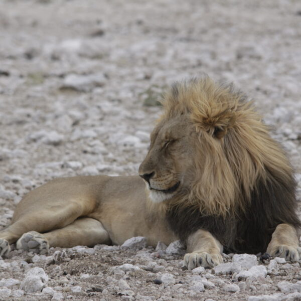
The Etosha National Park covers an area of over 22,000 square kilometers and was declared a wildlife sanctuary in 1907. In the center is an extensive salt pan, about 5,000 square kilometers in size, surrounded by grass savannas, light bushland in the west and dry forest in the northeast.
Gravel roads lead to the waterholes, where it is best to observe the game. There are three major state rest camps, Okaukuejo in the central part of the national Park, Namutoni in the east and the Halali Camp in between.
Almost the entire range of African game is represented in the park.
Etosha National Park is open all year round, every day from sunrise to sunset. At nightfall you have to be in one of the rest camps or leave the park beforehand.
Join our mailing list to get the latest news, updates and special offers delivered directly to your inbox.