
The Destination makes the journey
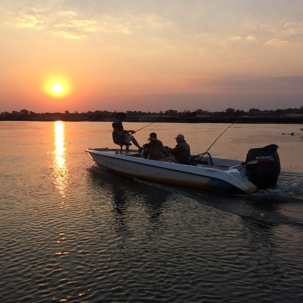
The Panhandle region, situated beyond the protective barriers of the Delta ecosystem, offers a captivating array of wildlife and an abundance of avian species. Notably, one can encounter magnificent creatures like hippos, elephants, and crocodiles here. Moreover, this region is home to thriving traditional communities whose lives revolve around the perennial Okavango River. The Panhandle is a highly sought-after destination for various activities such as boating, mokoro rides, kayaking, fishing, bird-watching, and houseboat expeditions. Fishing enthusiasts, in particular, cannot afford to miss the incredible Tiger fishing and Barbel Run experiences, which are bound to be among their most cherished memories.

Discover the captivating western region of Botswana, renowned for its thriving cattle farming industry. Not only is it a perfect pit stop for restocking your supplies while camping, but it also offers convenient access to the magnificent Moremi National Park and the enchanting northern area of Shakawe, serving as the gateway to the breathtaking Okavango Delta. Just 35km north of Ghanzi lies the charming village of D’Kar, where you can immerse yourself in the rich culture and traditions of the bushmen people and their close-knit family groups.
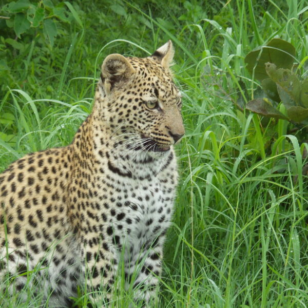
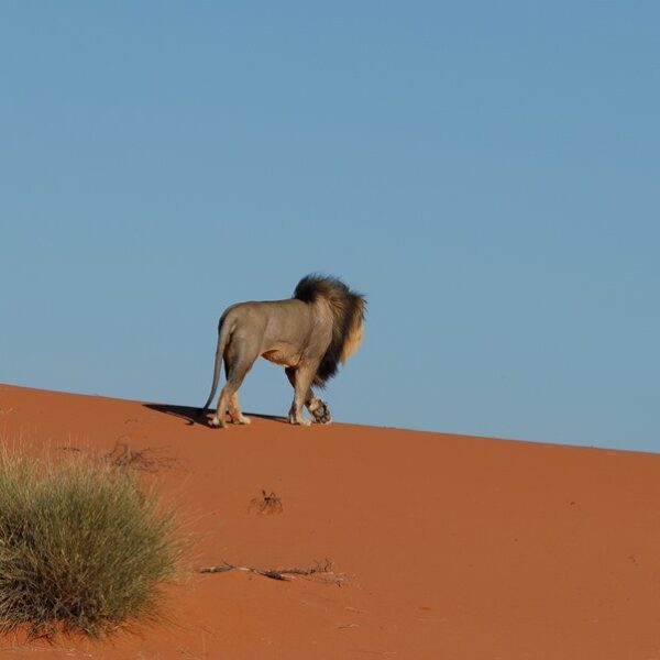
The Chobe National Park is the biggest in the Chobe/Kasane region. It is one of the largest parks in Botswana. Its landscape varies from floodplains, dense Mopane forests, and savanna to grasslands. You can expect to see a magnificent wealth of game, e.g. giraffes, a wide variety of Antelopes, Hippos, Buffalo, lions, bat-eared foxes, cheetah wild-dog, leopards etc. and also a massive population of elephants. Kasane is the main town of this region and is a tourist hub. Kasane also offers boat trips for game viewing on the Chobe River.
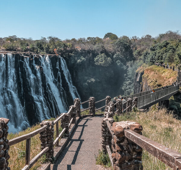
The Scottish missionary David Livingstone identified the falls in 1855, and naming them Victoria Falls after Queen Victoria. Since the mid 20th century, the site is growing to be a very important source of tourism to both Zimbabwe and Zambia, situated approx. 10km outside the city of Livingstone. It is known as one of the world’s seven natural wonders and one of the most spectacular natural sites in the world.
The Falls are 1.7 km wide with a volume of between 20,000 and 700,000 cubic metres per minute, falling down a vertical drop of 100 metres. The spray of the Falls can be seen from a distance of 30km and hereafter its local name, Mosi-oa-Tunya, “The smoke that thunders.”
Due to the increasing levels of tourism and the region’s development, it has become known as a centre for adventure sports. Activities gained attractiveness in the area, including white-water rafting in the gorges, bungee jumping from the bridge, game fishing, horse riding, kayaking, and flights over the falls.
The Omaheke Region ( Hereo language: Sandveld) region lies on the eastern border of Namibia and comprises the district of Gobabis as well as former Hereroland East. A large part of this region, notably the former Hereroland East area, is known as the Sandveld. Because of its location and inaccessibility from other parts of Namibia, this region, although sparsely populated, forms an economic and administrative unit. Gobabis is the main centre of this area and also its main business hub, as it is linked with the capital of Namibia by rail and tarred road.
It is the region that mainly focuses on agricultural patterns and is to a large extent consistent. Most of the 900 commercial/3 500 communal farmers in this area are cattle breeders. The potential for developing this area is high. A factor which plays a major role in this respect is the development of the tarred road (the Trans-Kalahari Highway) connecting Namibia with Botswana and other parts of Africa.
The Capital of Namibia, Windhoek, is surrounded by mountain ranges and lives at an altitude of approx. 1700 above sea level. Hence there is no possibility of having an International Airport within the Towns boundaries. 45km to the East is the International Airport, the main port of entry for International and Regional Flight arrivals. Several Guest farms, Lodges, and also Wellness Retreats are within spitting distance from town. Just a drive of approx. 1 hour and you will reach the first farming lands, relaxing weekend resorts, and possibilities to enjoy several sport activities.

Walvis Bay, is the area where most of tourist go when visiting Walvis Bay but definitely worth a visit. You can go for a boat cruise, see flamingos at the lagoon and they also have some good restaurants and little shops. Other than that, Walvis Bay is a port town, constantly busy with fishing boats and ships. Another highlight is the well know Dune 7, just outside of town. The Area is also known for the collection of guano and salt mining .
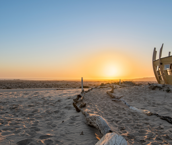
The Skeleton Coast Park covers an area of approx. 16 845 km² along the northern Westcoast of Namibia. It is know for its shipwrecks, its rescues and stories of brave survivors. Thick fog, strong winds and cold Benguela current make this a difficult part of the ocean to safely navigate. Torra Bay and Terrace Bay are two of the Parks outposts, and are very popular with fishermen.
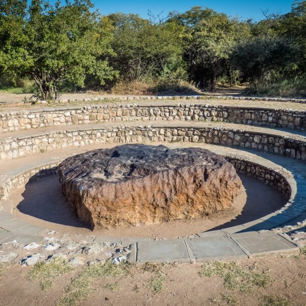
Otjozondjupa is part of the central regions in Namibia with various vegetation ranging from open savanna around Otjiwarongo Area, to lush vegetation which you can find in the main attraction area, Waterberg National park, and further north the Hoba meteorite close to the town of Grootfontein.
The Hoba meteorite near Grootfontein, is a National Monument in Namibia and popular among tourists reason being, that this is the largest piece of iron ever found near Earth’s surface, weighing 66tons.
Most of the Accommodation offered would be in the Waterberg Plateau area.
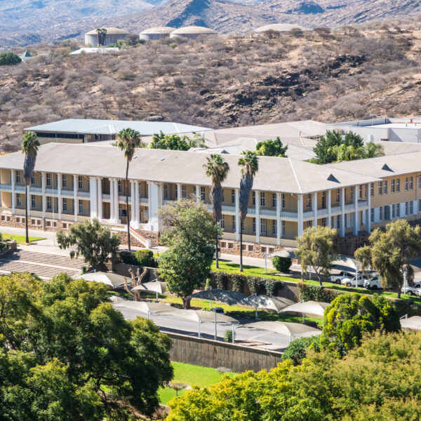
Windhoek, with its now over 500,000 inhabitants, is the largest city in Namibia. The pretty capital is located at an altitude of 1650 meters, in a basin of mountain ranges, lined by the Eros Mountains in the north and the Auas Mountains in the south. To the west, the Khomas Highlands stretch towards the Namib and the coast. The influence of the German language and culture can be seen in many areas due to the colonial past.
Particularly worth seeing are the “Ink Palace”, Namibia’s parliament building, the Christuskirche of the Lutheran community from 1896, the new bombastic Independence Museum right next to it and the “Alte Feste”, once the headquarters of the protection force and now the Namibian National Museum.
The Waterberg Plateau, located 70 kilometers east of Otjiwarongo, rises about 200 meters from the surrounding sandy Kalahari Plain. The 20-kilometer-wide and 50-kilometer-long Table Mountain massif consists of porous sandstone. Precipitation seeps through the porous rock and hits a water-impermeable clay layer at the bottom. While it is very dry at the top of the plateau, there is a lot of surface water and strong permanent springs at the foot. The vegetation is lush and green and especially rich in species. Among other things, you can see wild fig trees, fire lilies and coral trees here. The Waterberg traditionally belonged to the settlement area of the Herero people. The Hereros, who once settled here, called the place “The Place of Fat Cows”. This is still confirmed today because some of the best cattle farms are located in the Otjiwarongo area.
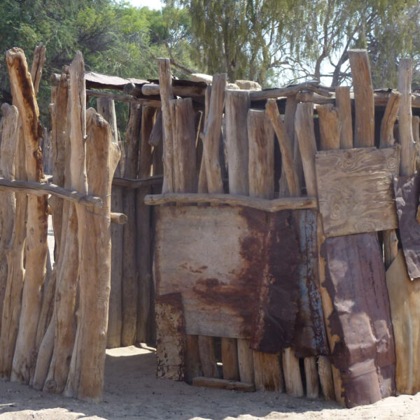
Do you want to know the traditional life of the Hereros. In the center of each settlement is the Cattle kraal, a fence made of long wooden sticks. In particular, the kraal protects the herd from night attacks of predators.
This huge desert area is part of the large inland basin in southern Africa. Because of its porous and sandy soil, which does not allow water resorption, the Kalahari is still called a desert, but in reality it is a wilderness filled with life, on whose grass-covered areas many herds of game and other animals live.
The Kalahari is the former main settlement area of the San. The San are organized in small families and live as nomadic hunter-gatherers. The family is fed by the rich wild stock of the Kalahari and the fruits and roots found here. They obtain water from water-storing plants
The annual amount of precipitation in the south and west is around 150-250 mm, while in the north and east it rises to over 500 mm, so the climate there is sub-humid. The Kalahari, except for this area, is located in a continental arid climate zone. It is characterized by long dry periods.

One of the most famous landmarks of Namibia is the Spitzkoppe rock massif consisting of granite rocks and belongs to the Erongo mountain region, which was formed more than 100 million years ago by volcanic activity and subsequent erosion. Magma penetrated upwards, but not to the surface. Due to wind erosion, the loose sand mass was subsequently eroded over millions of years until the granite intrusion was exposed.
You can hike extensively in this fascinating landscape and climb around among the bizarre rock formations. Also, this area is often visited by locals who are here in search of semi-precious stones. The Brandberg, located about 150 kilometers northeast of Henties Bay, is a granite massif, also formed by volcanic activity and subsequent erosion. The rough-looking and very dark-looking mountain covers an area of 760 square kilometers and towers over the surrounding land by about 2000 meters. The highest elevation is the Königstein, with 2573 meters and thus the highest mountain in Namibia

It extends south of the Kaokoveld to the skeleton coast to the west. This also includes the Grootberg and the Brandberg Massif as well as the northern foothills of the Große Randstufe. Driving through the area you will experience again and again stunning landscapes with bizarre mountains and wide stony plains. You rarely come across people and settlements. For this, there are still wild rhinos and desert elephants, mainly in the western part.
About 100 kilometers west of the city of Khorixas, you will find the main attractions declared by UNESCO World Cultural Heritage, prehistoric rock engravings. The engravings are located on smooth slabs of reddish sandstone and represent mainly animals or animal tracks. Also worth seeing is the Damara Living Museum near Twyfelfontein, an open-air museum that reflects the culture and traditional way of life of the Damara people.
The basalt columns, known as “organ pipes”, are up to 5 meters high and were created 120 million years ago. Lava penetrated the shale rock under high pressure and was later exposed by persistent erosion. The columns are located below the road along a ravine. The razor-sharp edges of the columns are unique. These should be handled with caution.
The “Petrified Forest” is located 40 kilometers west of Khorixas. Here you can find the fossilized remains of 280 million-year-old tree trunks. In 1950, the place was declared a national monument.
Further north you will find Fort Sesfontein. During the German colonial period, this was a base for protection against the predatory Swartbooi Namas. The First World War led to the abandonment of the station. The old fort was restored a few years ago and turned into a lodge. It is considered a gateway to the Kaokoveld.
Another highlight in Damaraland are the Ugab terraces and the 35 meter high Vingerklip rock dome.
The quiver tree is one of the aloes that are often photographed at sunset. The “quiver tree forest” on the Gariganus Farm is best photographed in the late afternoon or at sunset. The farm is located about 13 km northeast of Keetmanshoop. The access road is well signposted, but not asphalted. In the immediate vicinity of the quiver tree forest is the “Giants’ Playground” (“Playground of the giants”), which has been declared a tourist attraction by the farm owner. A bizarre natural wonder are the perfectly balanced accumulations of volcanic boulders, which have been smoothed over the years by wind and weather, and resembles the playground of the giants. A circular hiking trail of just under an hour leads through a bizarre rocky landscape.
The environment is becoming denser and greener, trees are becoming more numerous. Free-roaming goats, sheep and cattle move between the settlements, and fields with corn and millet, and unexpectedly cross the roadway due to the lack of fences. On the roadside, woodcarvers sit in front of their huts and shelters and offer their carving work. The transport of water to the villages is unique, namely with environmentally friendly ox-drawn sledges.
The district capital, Rundu, is located on a small hill directly on the Kavango River. This is the lifeline of this region . Over a length of more than 400 kilometres, the Kavango River marks the border between Namibia and Angola before turning south into the Okavango Delta
200 Kilometers east of Rundu, near the village of Divundu, is one of the scenic highlights, the Popa Falls. The Popa Falls are not really a waterfall, but only rapids, which looks more impressive in deep water than in high water, because then the rock reef stands out more strongly from the riverbed.
The national parks such as Mahango Park are home to a range of animals, including hippos.

Tsumeb is located in the so-called “Otavi Triangle”, which refers to the area between the towns of Tsumeb, Otavi in the southwest and Grootfontein in the southeast. The Otavi Triangle receives relatively high rainfall, so that agriculture, such as corn, cotton and sunflowers can be harvested in this region.
The Tsumeb Museum was founded in 1976 by Ilse Schatz, a dedicated and knowledgeable farmer’s wife
The museum is located in the main street of the mining town Tsumeb. The museum owns and exhibits an extensive mineral collection and provides extensive information about mining in Tsumeb and the history of the city, . 25 Kilometers northwest of Tsumeb is Lake Otjikoto, around which many stories and myths are entwined. The lake has a diameter of only 100 meters and – together with the nearby Guinas Lake – is the only natural underground lake in Namibia. Otjikoto Lake has an extreme depth of 120 meters. It is actually a collapsed cave that leads obliquely into the depths. In July 1915, the German Schutztruppe sank its last cannons and rifles in the lake before surrendering to the overpowering South African troops. Some of these guns were recovered from the lake at the end of the 80s and carefully restored and are now exhibited in the Tsumeb Museum
The “Ovamboland” , former homeland of the Ovambo north of the Etosha Pan, was divided into the 4 districts Omusati, Ohangwena, Oshana and Oshikoto after the independence of Namibia.
13 kilometers southwest of Ondangwa is the former Finnish mission station Olukonda. The church building is now a national monument and is under the care of the Evangelical Lutheran Church of Namibia. Next to the old church , the Nakambale Museum was built in 1995.
The Ovambo’s are small-scale farmers and cultivate crops by hand on the nutrient-poor and depleted soils, especially mahango and sorghum cultivation. The landscape is flat, monotonous and overpopulated. There are isolated trees between the fields and fields, or the typical Makalani palm trees from whose fruits or the core are processed into artistic carvings and sold as souvenirs.

The Namib-Naukluft Park is Namibia’s largest nature reserve with a total area of around 50,000 square kilometers. It comprises a belt about 100 to 150 kilometres wide along the Namibian coastal desert, which begins in the north at the Swakop River valley and extends in the south to Lüderitz. The relevant part of this huge area is a concession area and is not accessible to people.
The northern part between Swakop and Kuiseb is called the Namib Section. A wide gravel road leads from Walvis Bay through the Namib Naukluft Park and gives an impression of the imposing landscapes of rugged mountain massifs and gravel plains. After passing the Kuiseb Rivier Bridge, you leave the park area.
Welwitchia Drive
The “Welwitschia Mirabilis” is probably the most famous plant in Namibia. She is about 1000 years old, in some cases also older. in 1859, the ‘living fossil’ was first discovered by the Austrian botanist Dr. Welwitsch and therefore named after him. The Welwitschia plant has only two leaves, which, however, are frayed by the wind over the years. It absorbs the water necessary for its growth via the humidity.
Welwitschias grow exclusively in the middle part of the Namib, about 40 to 120 kilometers from the coast. You can find the strange plants on the signposted Welwitschia Drive. A more interesting sight is the ride leads the bizarre, almost vegetation-free “lunar landscape” along the Swakop Riviera. Around 450 million years ago, soft rock layers were deposited here, into which the river ate its way.
The scenic highlight in the Namib Naukluft Park is the drive to the Sossusvlei. It is located in the middle of the central Namib dunes, which make up the largest part of the park with an area of about 32,000 square kilometers.

Swakopmund was of great importance as a port during the German colonial period. Since the coastal waters are actually too shallow, a protected bay is missing and the surf is too strong, this attempt has failed.
Today Swakopmund is a popular holiday town for visitors offering many tourist attractions.
Swakopmund’s surrounding area also has a lot to offer. Particularly attractive are trips along the magnificent dune-lined coast, both to Walvis Bay, located 30 kilometers to the south, with its peaceful lagoon. The lagoon is a bird paradise. Especially impressive are the flamingos, which are usually very numerous near the shore looking for crayfish.
On a clear day, you can see the striking black and white lighthouse on the tip of the headland in the northwest of the lagoon.
In addition, sea salt is produced in Walvis Bay. 400,000 tons of high-quality salt are extracted annually on the 3,500 hectare salt fields
Dune 7
Sandboarding is permitted on the approximately 130-meter-high sand dune. Pure quadbike tours are also possible, one-hour or two-hour. Since it is easy to get lost in the almost endless dune world, quadbiking should only be done in the company of a guide.
Historic buildings
The beautiful historical buildings in Swakopmund – Hohenzollern House, Woermann House, Old District Court, Princess Rupprecht’s home, cable fair, “Knight’s Castle” – can be easily got to know during a stroll through the city.
Crystal Gallery Swakopmund
The Crystal Gallery in Swakopmund, on the corner of Tobias Hainyeko and Theo-Ben Gurirab Avenue, is definitely worth a visit. In modern designed rooms, the entire variety of ores and minerals to be found in Namibia is exhibited here, tourmalines, amethysts, aquamarines, dioptase, quartzes and much more. Particularly impressive is a giant quartz weighing 14 tons, the crystal is 3 meters wide and just as high, and the exposure took several years.
North of Swakopmund : Henties Bay, Cape Cross
A road leads directly along the beach to Henties Bay, and then to Cape Cross to the mouth of the Ugab River. This is where the Skeleton Coast National Park begins
Henties Bay is a fishing paradise and is fully dedicated to fishing tourism.
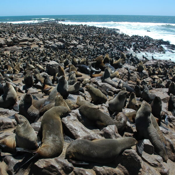
Cape Cross is a popular tourist destination, especially because of the nearby seal colony. At times, more than 100,000 dwarf fur seals, also called “eared seals”, gather here . You can get quite close to the animals via a wooden footbridge. The rather unpleasant stench is not for people with sensitive stomachs.
Cape Cross is part of the Dorob National Park, which was proclaimed in 2010. In the language of the Damara, Dorob means “water that sinks in the sand”.

The former Caprivi Strip (today Zambezi region), is a bulge in the northeast of Namibia. Drawing the border and naming it after Leo von Caprivi, it dates back to the colonial prehistory of the country as German South-West Africa.
The Caprivi is the most water-rich region in Namibia. The area is surrounded by the Okavango, ,Kwando, and Zambezi rivers, all of which originate in Angola. In addition, there are also rivers such as the Linyanti and the Chobe.
The abundance of water in the Caprivi ensures an immeasurable wildlife population, in addition, to a large number of elephants. Although there are no border fences, the game is protected and allows the animals to move relatively undisturbed to the neighboring countries of Botswana and Zambia.
The entire western Caprivi is now a wildlife sanctuary. In 2002, the former Mahango Game Park and the West Caprivi Game Park were combined to form the Bwabwata National Park. In East Caprivi there are two other game reserves, Mudumo National Park and the wide-ranging Mamili National Park
Both national parks are home mainly to large population to elephants, but also rare antelope species, zebras, hippos, crocodiles and over 430 bird species.

The dunes in the Namib Desert were formed over the course of many millions of years. Sand,which was constantly washed into the sea by the Orange River, was transported northwards along the west coast by the cold Benguela Current. The surf pushed the sand ashore. Coastal dunes were formed, which were shifted inland by the wind. The wind is still constantly shifting the sand of the shifting dunes
Namibia’s scenic highlight in the middle of the Namib Desert is the Sossusvlei in the Namib Naukluft Park – is a salt-encrusted clay depression surrounded by mighty sand dunes. In 2013, the area was declared a UNESCO World Heritage Site. The dunes in the Sossusvlei sometimes reach heights of 300 meters and more and are therefore among the highest in the world. The record is held by the 350-meter-high “Big Daddy” or “Big Mama”.
The Tsauchab River has created as a gorge millions of years ago with steep and almost vertical conglomerate rock walls rising upwards, sometimes up to 30 meters. The incision is only a few meters wide. This is the nearby Sesriem Canyon. The Tsauchab Rivier supplies the water after a good rainfall, especially from the Naukluft mountains through the canyon to the Sossusvlei. This event is extremely rare.
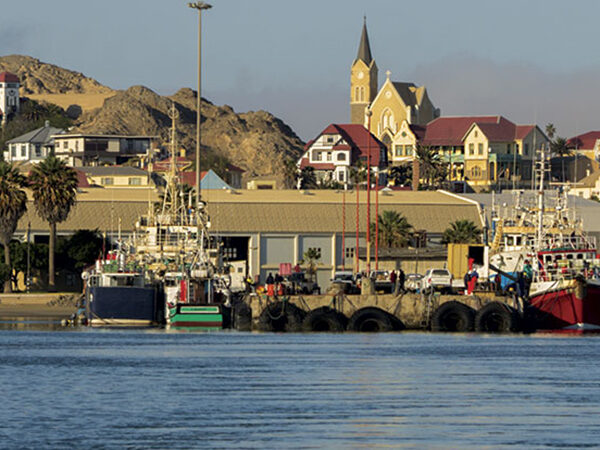
Lüderitz and its surroundings
The small village of Aus is located about 125 kilometers east of Lüderitz. West of Aus begins the “Dune Namib”, and here you can mostly see a herd of wild horses
Garup was once a small railway station on the railway line from Aus to Lüderitz, completed in 1906. The small station house and the remains of the railway tracks as well as the water reservoir for the steam locomotive can still be visited today.
For the visitor, the nostalgic Lüderitz reveals itself as a very colorful small town, due to the numerous buildings originating from the German colonial period and lovingly maintained in the then popular Art Nouveau and Wilhelminian architectural style. The Evangelical Lutheran rock church from 1911 on the highest level of the city is striking, as well as the Goerke House with its bright blue roof and its grandiose sundial.A visit to the Lüderitz Museum is very worthwhile
Kolmanskop (Kolmanskuppe)
Of particular interest is the ghost town of Kolmanskop, once the center of the diamond industry in Namibia. Within two years after the first diamond was found, Kolmanskuppe was created. A complete place with a school, a first-class equipped hospital, an ice cream factory, a casino with a bowling alley, bakery, butcher and other facilities, as well as exclusive and pompous residential houses. Today this place is abandoned, and dunes have taken over the buildings and give the place a spooky atmosphere.
Big Bay
A trip around the lagoon and Sturmvogel Bay and Große Bucht to the Lüderitz Peninsula with Diaz Point is recommended. There is a small penguin colony on Halifax Island.
Shark Peninsula
The little trip to Shark Island, where the Lüderitz monument is also located, is worth it. From here you have a wonderful view of the Atlantic Ocean, the harbour entrance and the city
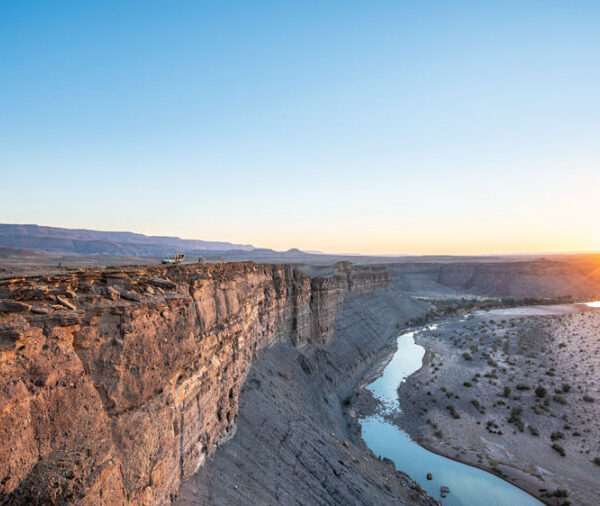
The Fish River is the second longest river in Namibia with somewhat 650 kilometers. It originates in the eastern Naukluft Mountains and flows southwest of Ai-Ais into the Oranje River. Since the Fish River is already dammed in Hardap near Mariental, it usually carries only small amounts of water with it. In winter, during the dry season, you often see no water at all or only individual puddles.
The hike through the Fish River Canyon may only be carried out between 1 May to 15 September, i.e. in winter. In summer temperatures are too extreme for hiking.
The deep gorge of the fish River is not only an event of severe erosion, but at the same time a consequence of flexures and breakup of the shallow Nama layers.
From the Fish River Canyon it is only a short jump to Ai-Ais at the southernmost end of the canyon. Hot thermal water gushes from the springs of Ai-Ais. It is around 60 ° C hot and rich in sulfates, chlorides and fluorides. ‘Ai-Ais’ means ‘burning water’ in the Nama language.
The Kaokoveld is very wild. Again and again you can see oryx antelopes, springboks, kudus or giraffes, mostly in the sandy dry rivers, in the shade of acacia trees. With a little luck you can also see the famous desert elephants.
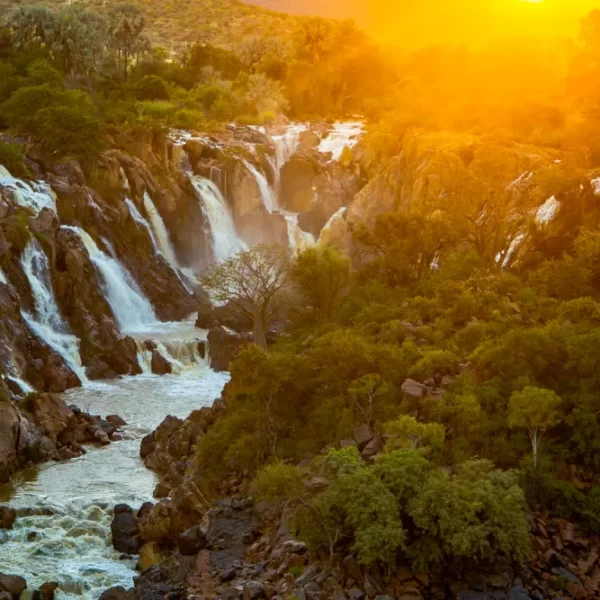
The capital of the Ovahimba, Opuwo, is located in the middle of the Kaokoland and offers shopping opportunities to the surrounding villages of the Normaden. Also, this area is a part of the Kunene region, where the Epupa Waterfalls, further east the Ruacana Falls are located, which fill only with good rainfall in the neighboring country of Angola.
The modest and semi-nomadic shepherd people, the Ovahimba, were able to largely preserve their ethnic identity and culture in the seclusion of the Kaokoland. The friendly people mainly breed cattle, fat–tailed sheep and goats, and – depending on the season – they move with their flocks to different, not dried-up watering places. Their small mud huts offer them a protective place to stay, because it can get very hot there.
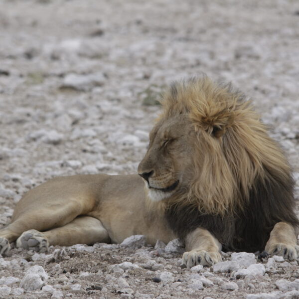
The Etosha National Park covers an area of over 22,000 square kilometers and was declared a wildlife sanctuary in 1907. In the center is an extensive salt pan, about 5,000 square kilometers in size, surrounded by grass savannas, light bushland in the west and dry forest in the northeast.
Gravel roads lead to the waterholes, where it is best to observe the game. There are three major state rest camps, Okaukuejo in the central part of the national Park, Namutoni in the east and the Halali Camp in between.
Almost the entire range of African game is represented in the park.
Etosha National Park is open all year round, every day from sunrise to sunset. At nightfall you have to be in one of the rest camps or leave the park beforehand.